
Bolivia
Bolivia is one of the poorest countries in South America and also the country with the highest percentage of native americans in the population. This is not entirely a coincidence and the large social and economic divisions can be quite disturbing. However the people are very easy going and the mountains are spectacular, generally very accessible, and have superb, very settled weather in the dry season from May to Auguat..
The Cordillera Real
Bolivia's highest and most extensive mountain range, the Cordillera Real, lie immediately above the capital city La Paz. The city has a spectacular setting in a deep canyon on the edge of the high plateau known as the 'Altiplano' with magnificent views to the huge mountain Illimani. The international airport is up on the Altiplano at almost 4100m, so you will feel the effects of high altitude as soon as you land. You might even need to use the oxygen they have waiting at baggage reclaim!
Many people feel poorly for a few days after arriving in La Paz, and a few days of taking it easy are recommended for everyone. There are interesting tourists trips possible from the city including a boat trip on the famous Lago Titicaca and the pre-Inca ruins at Tiahuanaco. Once you get over the initial problems, the high altitude of La Paz makes the city a great base for trekking in the Cordillera Real with good restaurants and supermarkets and the mountains only a couple of hours drive away.
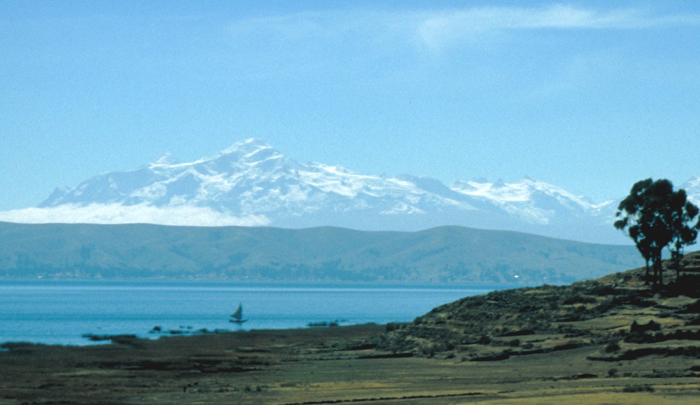 Ancohuma from Lago Titicaca.
TREKKING
It is often possible to start a trek high in the Cordillera Real near La Paz and finish in a jungle town in the foothills. The Takesi trail from Ventilla to Chollja takes only a couple of days but follows a well preserved ancient paved highway down and around steep hillsides. It crosses a big pass on the first day but is otherwise a relatively easy downhill walk. Another famous trek is the La Cumbre to Coroico, or (Choro Trail) route, which begins at the pass of La Cumbre just an hour from La Paz. After crossing a small pass used by local llama herders this four day trekking route is entirely downhill to the jungle town of Coroico at 1500m. If you want to extend this trek you can start in the Milluni valley and traverse the high mountains to La Cumbre first. The road back to La Paz from Coroico is probably the world's most frightening bus journey!
In the north of the range the trekking is more adventurous with fewer people and tougher trails. The Illampu Circuit, Camino de Oro and Mapiri trail are amongst the best. A grand traverse of the whole range from Illimani to Illampu (or vice versa) can even be done, walking mostly on the lower slopes and crossing numerous passes. This will take about three weeks altogether starting on the west side of the range at the southern end and crossing to the eastern side of the range after the Khara Kota valley.
CLIMBING
The Cordillera Real makes a great venue for a climbing trip - the peaks are relatively accessible, the scenery is great and there are peaks at all levels of difficulty. Popular areas and peaks include the area around Condoriri and Pequeño Alpamayo, Illimani the highest in the range, and Huayna Potosi. At the north end of the range, rising above the beautiful wee town of Sorata are the slightly more difficult peaks of Ancohuma and Illampu
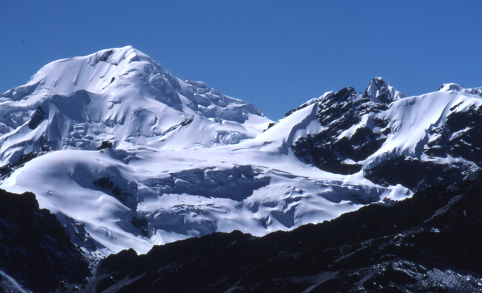
 Campsite in the Cordillera Real.
SKIING & SKI-MOUNTAINEERING
One of the more unusual attractions of the Cordillera Real is the world's highest ski "resort". Don't come half way round the world for a skiing holiday though - there's only one broken tow, you have to hang on to it to the point of exhaustion and it may not be running anyway!
This is on a mountain called Chacaltaya on the outskirts of La Paz and skiing is sometimes possible at an altitude of about 5100m. However conditions have not been good for many years now. The piste gets a bit icy in the dry season and the wet season from November to March may be better. The views are great and the excursion, which can be easily arranged in La Paz, is recommended even if there is no snow or for non-skiers.
However there are lots of good ski-mountaineering possibilities in the Bolivian Andes, although the skiing is all at altitudes of over 5000m and sometimes requires a bit of a climb to reach the snow-line. Of the really big peaks Mururata is the one that really stands out as a good ski peak, but Illimani and Huayna Potosi have also been skiied..
BIKING
Mountain biking has become popular in the Cordillera Real recently and a number of agencies in La Paz now offer bike hire and escorted tours, either for one day or several days. As in Ecuador and the Cuzco area the emphasis is definitely in getting in lots of downhill mileage, with descents from 4500m to near sea level being possible in one day. You'll need to check your bike has good brakes!
Cordillera Apolobamba
North of the Cordillera Real and straddling the Peruvian border are the Cordillera Apolobamba with many peaks over 5000m. This is a remote mountain range and just getting to the start of your trek will prove to be quite an adventure. There are a number of good treks, the most popular is the five day walk from Curva to Pelechuco.
There are several straightforward 5000m+ peaks in this range too, such as Cuchillo, Ascarani and Mirador. The highest peak in the range is called Chaupi Orco, and is just over 6000m high.
Chaupi Orco is the highest peak in the Apolobamba.
The Cordillera Occidental
The Cordillera Occidental are a range of isolated volcanic peaks on Bolivia's western border with Chile and containing the country's highest peak, Nevado Sajama 6550m. This area has some of the most desolate but beautiful scenery in the Andes and is a good place to see wildlife. Particularly famous is the Lauca National Park (actually in Chile) where you will easily see condors, vicuñas and flamingos and possibly even the rhea. On the border is the beautiful Volcan Parinacota 6342m, a perfect volcanic cone covered in pure white snow. This is an easy ascent though you will need an ice-axe and crampons; it also makes for a great ski descent if conditions are right.
If that seems too much there are magnificent walks around the base of the mountain passing high altitude lagoons rich in bird life and eerie volcanic formations such as fresh lava flows and cinder cones. A complete circuit of Parinacota and its twin volcano Pomerape can be done in 5-6 days depending on where you start. Donkeys can be arranged in the village of Sajama for this excursion and you'll also get basic accommodation in the village. Access to this remote mountain area is by the La Paz-Arica bus, which runs twice a week along a brand new tarred road.
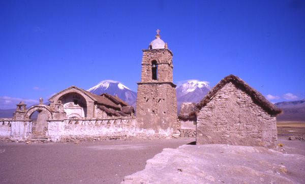
Parinacota and Pomerape from the village of Sajama.
Bolivia Factfile
When to go - The winter months of April to October have the driest and most stable weather. May, June and July are the best months. It will be cold at night though, especially on the altiplano over 4500m.
Weather - Expect lots of very dry clear days in the dry season, but with bitterly cold nights. Expect overnight low temperatures of -10ºC
Flights - Flights from London to La Paz cost from £1000 upwards. There are no direct flights from Europe, so you'll need to fly via Sao Paulo, Lima or Bogota. The best deals are usually with either LATAM or Avianca.
Guidebooks - John
Biggar's
guidebooks 'The Andes - A Guide for Climbers and Skiers' provides details of the easy trekking peaks
mentioned here..
